
This month we wind up our trip to southern Utah with a stop at Zion National Park. Before we left on our trip in October, I talked to a friend who spends the winter months in this part of the world hiking and such, and based on that, I prioritized spending more time in Bryce Canyon and less at Zion. I got it dead wrong. Now not to take anything away from Bryce, but it’s more of a cute fairy land in contrast to the jaw dropping scale and beauty of Zion. Now I know WHY they named it Zion. Of course, that came from the early Mormon settlers, but they got it right.
We entered Zion from high elevation in the northeast corner, coming from Bryce and Kodachrome. From the moment we entered the park, we began to enjoy a landscape unlike anything we had ever seen. Soaring, huge, beautiful slabs of sandstone in a myriad of formations and colors. Trees dotting these slopes like pepper on your mashed potatoes. And more Utah red rock and Utah blue skies.
The road wound around through a maze of mountains and cliffs. We stopped for a photo op of Desert Bighorn Sheep. Then stop. What’s this, a line? This must finally be the famous tunnel. We take a quick break and then see cars coming from the opposite direction. Time to jump back into the car and we start rolling. The tunnel was built back in the twenties, so there is only room for one-way traffic with our modern trailers and motorhomes. We pass the guard and enter the tunnel and click clack along. The road starts to curve and wind. Down we go, dotted with the occasional window in the rock. It goes for 1.1 miles but seems longer.
Nothing I say can prepare you for what comes next. The road simply opens out at the base of a thousand-foot cliff, with a view of the entire Zion valley that sucks the breath right out of you. Partly because you are immediately plunged into steep switchbacks to descend another 500 feet to the valley floor. I am including some photos, but nothing I have done can capture the 360-degree experience.
Since we went in October, I can’t imagine what the summer must be like, with heat and many times the number of travelers. Actually, I can, since I barely got reservations a month ahead to stay in the lovely little town of Springdale. We are not really campers these days, so the town was perfect, with many places to stay and eat, along with galleries and craft emporiums around every corner. We really wanted more time to explore there. The town butts right up to the entrance of the park and each has their own shuttle system. Both are free. You stay at a motel, which are generally more expensive the closer you get to the park, then just take a shuttle back and forth as there is really only one road in town. We hop off at the end of the shuttle line in town, walk across the parking lot, entering the park again, and jump on the park shuttle to sightseeing and the lodge.
You are unable to drive into the main Zion valley in your car at any time except the winter. If you have been to very many parks, you are probably used to this by now and it makes things easy and enjoyable.We made a quick afternoon/evening run into the valley and did a little hiking. Like any stream laden valleys, it is lined with all sorts of deciduous trees in a flat plain. We hiked up the famous Zion Narrows but stopped where the trail ends and wading begins. That hike we are saving for the next trip when we bring our boots and waders and have more time.

The Watchman at sunset, viewed from in town

Majesty – The grandeur and majesty of Zion. This is what it looks like everywhere you turn.

Angles – The sandstone in Zion often looks like God just smashed a bunch of rocks together.

Zion Slope – Trees emerge straight out of the sandstone slopes.

Desert Bighorn – A group of Desert Bighorn sheep.

Zion Pinyon 1 – Pinyon Pine emerging from the sandstone.

Zion Pinyon 2 – Perfect bonsai inspiration in a Pinyon.

Live Oak – Foliage of a small Live Oak, unknown variety.

Cacti – it’s that dry

Viewpoint Trail – The Overlook Trail. The trail follows the base of the red rocks. The catwalk can be seen at the middle left of the photo where it swings out, then under the rocks.

Zion Tunnel – The Zion Tunnel as seen from the Overlook. You can see the zigzag switchbacks in the road and where it enters the mountain at the base of the cliff on the left.
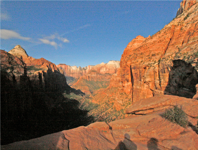
Overlook View – The view from the Overlook. The view is much wider than this. It has been compressed with a wide angle lens to get it all in
The next morning, we were able to head out early and drive back up on top where we had entered the park the previous day. Doing our research, our first destination was the Overlook Trail. Sounds promising, eh? The trail starts right where the tunnel begins. Be prepared. This is the most enjoyable short hike I have ever been on. Now to frame that, I love trees, I love the outdoors, I love exploring new vistas and scenery.
The trail is not hard and we made it out and back in an hour, with a twenty-minute layover to boot. The trail winds around a steep canyon, including a catwalk out over the canyon that swing back under an overhang. Around every turn there was an interesting tree (both deciduous and conifers) or interesting rock to scramble across, or a great view into the jagged canyon. The trail then gently climbs over a saddle to reveal the entire Zion valley as a reward. You see where the tunnel emerges from the cliff and realize how big that mountain really is. You can almost see both ends of the tunnel at once. The top is also broad enough to invite more exploring of trees, rocks, and scenery and open enough that no path is needed. Seeing the trees growing in these environments is simply marvelous and bonsai inspiring. I hope you get to make the journey soon.
Repotting
And just so that we can ease our way back into actual, applicable bonsai, here are a few thoughts on repotting. First of all, once you get all of that work done to get the tree safely into a bonsai pot, take care of it. Do not let it freeze. The act of repotting has taken away much of its winter hardiness, so they must be protected.
Secondly, give a very good watering after repotting, until the mucks washes away and water runs clear. Then don’t water until it needs it. That might be a week or more in our weather. The tree’s uptake system has just been pruned back, so it is not able to absorb as much moisture. It is sort of like cutting the sponge in half. It will only take half as much now. As the tree reestablished itself, it will tell you it needs more by drying out a little. The last thing we want to do is drown the roots and start a cycle of decay that is hard to break. Give it just what it needs. That means no fertilizer for a month either. Not only are you wasting it, and your time, the tree can possibly suffer. So, hold off for a bit. I always try to keep my trees out of the rain by putting them under the eaves for a week or two after repotting to make sure they don’t get too wet and this is a great jump start for the new tree/pot/soil system. If you are able to provide bottom heat, that would be even better.
Scott Elser


